|
Geoguardian presents environmental contents based on satellite images and maps. This website deals with environmental and related research interests and is frequently updated with the latest environmental content. Kithsiri Perera - USQ, QLD, Australia, 2005-2015 |
Environmental Contents Archive 2005 (selected)
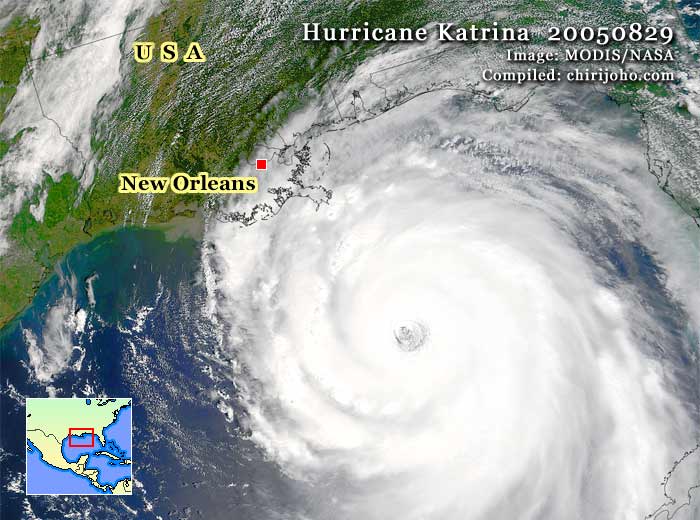
Hurricane Katrina
The disastrous hit of Hurricane Katrina on the southern coast of the US became the worst storm disaster in American history. Heavy rain and high sea waves drowned New Orleans, the city of 480,000 people, in seawater. This MODIS satellite image shows a closer view of deadly Katrina, before its landfall. This report was written after the landfall, and the latest information indicated that some hundreds of people might have killed by the disaster. In yesterday's MODIS image, the flooded region is visible through clouds (figure 01). Over 80% of New Orleans was flooded, and damage easily exceeded US$25 billion within the first few days.
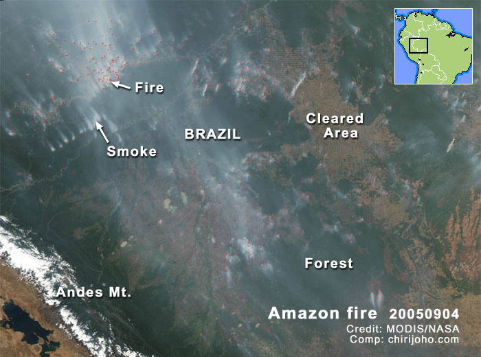
Raging Amazon forest fire
This MODIS satellite image is showing uncontrolled forest fire set for land clearance by Brazilian farmers. Fire is destroying even natural forests close to already cleared forests. These fires pose no major threat to villagers, but they contribute to global warming. Satellite data are a highly effective source for detecting and recording these types of fires in very remote locations.
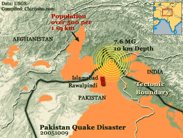
Pakistan earthquake
A disastrous big earthquake occurred in northeast Pakistan, in the disputed area with the Indian border. Magnitude 7.6 quake centred just near the Muzzafarabad city, which has about 0.2 million people. The weak building construction, shallow depth of the quake epicentre (10km), and aftermath landslides increased the death toll dramatically, passing 20,000 within the first three days. The map shows the hilly terrain of the region with some cities and the tectonic plate boundary. Pakistan government news says the Muzzafaeabad city has completely destroyed. Telephone, power, water, and other public services were downed and mountain villages became inaccessible due to damaged roads. Pakistan Meteorological Department says this is the worst quake hit this area in the last 100 years. The disaster occurred 10 months after the historical tsunami tragedy in Asia.
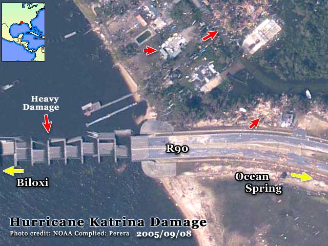
Hurricane damage
Hurricane Katrina, which demolished coastal Louisiana, Mississippi, and Alabama, became the costliest natural disaster in US history. Latest records say the death toll has passed 1,163 people, with a total economic damage of about $200 billion. This NOAA aerial photograph shows one of the hardest hit areas of the hurricane, the Biloxi city region, east of the New Orleans city of Louisiana. See the completely collapsed bridge and other damage locations (red arrows). The damage was accompanied by the after-hurricane flood caused by the broken levee system that protects New Orleans from Lake Pontchartrain. An estimated 1 million people were displaced, and about 5 million people lost power. Hurricane Katrina was a Category 5 hurricane and was also the 11th of the 21 storms that hit in this hurricane season.
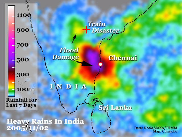
Heavy rains in India
Heavy rains associated with a storm flattened India's southeast region, including Chennai city in the Tamil Nadu district. Remote areas suffered severe flooding, including a fatal train accident near the Valigonda city in Andhra Pradesh (marked as a red + on the image). The train crashed into a river after the track was washed away by flood. The image shows these intense rains recorded over the last 7 days. Authorities say about 100 people or more were killed by the train disaster, apart from about another 100 deaths caused by the flood. Satellite data-based image shows heavy rains in purple colour (over 500 mm within the 7 days). These rainfall data are coming from the TRMM satellite, which is a joint project of the USA and Japan. TRMM data are useful to monitor rainfall conditions in remote areas and over oceans.
|
Geoguardian © 2005-2015. All rights reserved.