|
Geoguardian presents environmental contents based on satellite images and maps. This website deals with environmental and related research interests and is frequently updated with the latest environmental content. Kithsiri Perera - USQ, QLD, Australia, 2005-2015 |
Environmental Contents Archive 2006 (selected)
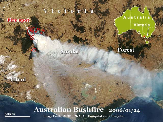
Australian Bushfire
Hot summer, lightning, and wind have contributed to igniting bushfires in southeast Australia. Now, disastrous bushfires are raging in Victoria, South Australia, and Western Australia. Three people were killed by fire-related incidents, and dozens of houses and thousands of hectares of bush (mixed vegetation of forest and grasslands) and farms were destroyed in the past few days. Firefighters are using water-bombing helicopters to contain large fires in Victoria. Today's satellite image shows one of the massive fires in Victoria. About 1/3 of the dark vegetation patch is affected by fire, as seen on this Jan. 24th MODIS satellite image. The vegetation patch is about 75km long. By today, most of the fires have considerable controlled with the help of mild wind and high humidity. Weather forecasters expect thunderstorms to hit Victoria in the next few days, which may have a contrasting impact with rain to decrease but lightning to ignite fires.
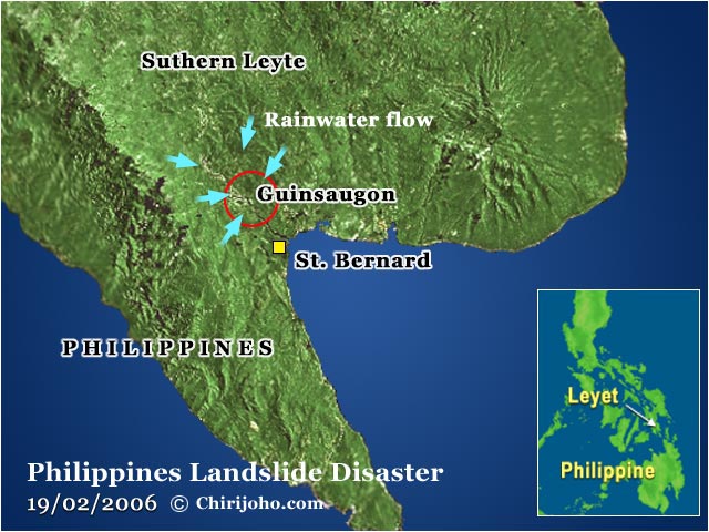
Landslide disaster in the Philippines
A disastrous landslide occurred in a country prone to natural disasters, the Philippines. After heavy rains of over 500mm hit the area within 10 days, a huge mountain area became a deadly landslide with a mudflow in Leyte Island of the central Philippines. The Guinsaugon village, with about 1800 residents, near St. Bernard city, was completely buried within a very short time, leaving only a few dozen survivors. When the soft soil layer soaked with rainwater, it slipped over the hard bedrock, creating the deadly muddy soil movement. Experts are partly blaming the deforestation in mountain slopes as one of the reasons apart from the heavy rains. Some argued that an excessive amount of rainfall, weak soil structure, and possibly the minor earthquake that occurred just before the landslide were the cause. Final toll of the disaster reported as 130 dead and over 900 missing, including 240 pupils and teachers of a primary school. After studying all geographical aspects of this disaster, authorities must act to identify landslide-vulnerable regions of the Philippines, as heavy rains are causing similar disasters frequently.
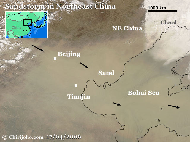
Sandstorms in NE China
Severe sandstorms choked millions of people in Beijing and the surrounding areas of China. Sand blew in from northeast Mongolia since 16th April and moved over the Beijing region by 17th April, causing the severest storm in the region this year. This latest MODIS satellite image shows the sand layer over Beijing and the Bohai Sea. These sand clouds then moved eastward and brought some difficulties to the Korean Peninsula and Japan. Reports say thousands of people in China faced breathing problems due to the heavy dust that came with the storm. Dry climate and poor farming practices in the northwest of the country are the main reasons for these storms. The Chinese government is planting huge green belts to minimise the impact of sandstorms on the capital and other populated areas.
|
Geoguardian © 2005-2015. All rights reserved.