|
Geoguardian presents environmental contents based on satellite images and maps. This website deals with environmental and related research interests and is frequently updated with the latest environmental content. Kithsiri Perera - USQ, QLD, Australia, 2005-2015 |
Environmental Contents Archive 2007 (selected)
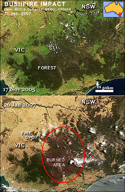
Impact of the Bushfire
Victoria, a state of Australia, has recovering from months-long bushfires, after thousands of acres of vegetated area were burned. The image pair here shows the forest area condition in late 2005 and the present. A huge patch of burned forest is visible in the 2006 image in dark red to brown colour. Also, compare the greenness between the two images. Many areas in Victoria and New South Wales are experiencing a severe drought, which is also the prime cause for heavy bushfires.
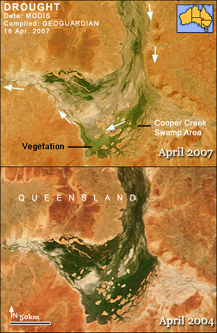
Worsening Australian drought
Severe drought in Australia is intensifying, despite the booming economy of the country, thanks to high global demand for Australian mining products. Queensland tightened water restrictions from level 4 to 5, and the Federal government is debating the idea of pumping northern New South Wales river water into southeast Queensland. Many inland farming communities have severely affected. Reports say the national wildlife icon, the koala population, is also hit by the drought due to a lack of water and fresh leaves to survive. This image compares the conditions in April 2004 and 2007 in the huge green area associated with Cooper Creek in Southwest Queensland. The vanishing green of the area is posing a great danger to the wildlife of these inland, isolated green areas.
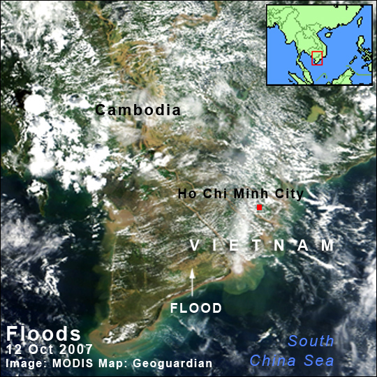
Vietnam Flood
Downgraded typhoon Lekima hit central Vietnam, killing over 70 people and damaging farmlands and infrastructure. This October 12th satellite image shows a rare view of partly cloud-free Vietnam and Cambodia. Yellow-coloured land areas are showing floods. Government estimations show at least 134,000 houses destroyed or damaged by the flood. Apart from the huge property damage, a considerable reduction of flood related deaths shows the strength of better flood warnings. But now authorities are concerned about possible disease outbreaks. Also, crop damage to rice fields may affect the rice price in the coming months. Thunderstorms will continue throughout the country in the coming days too, worsening the flood damage
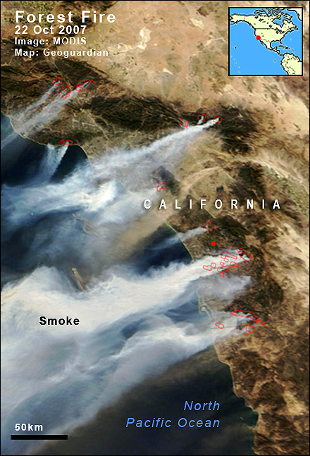
Raging fire in California
Drought and wind ignited a devastating forest fire in California, the USA. Within just 2 days, fire has destroyed over 700 houses and sent a quarter million people to safer places. The huge smoke columns rising from the fire are visible in today’s MODIS satellite image. The long path of the smoke indicates the aggressive wind in the area, which is further increasing the danger. The weather forecast expects more dry weather and high winds in the coming days, too. The Southeast coastal region of California is experiencing extreme drought conditions according to the US weather (NOAA) data.
|
Geoguardian © 2005-2015. All rights reserved.