|
Geoguardian presents environmental contents based on satellite images and maps. This website deals with environmental and related research interests and is frequently updated with the latest environmental content. Kithsiri Perera - USQ, QLD, Australia, 2005-2015 |
Environmental Contents Archive 2011 (selected)
Iceland Volcano blocked UK airspace
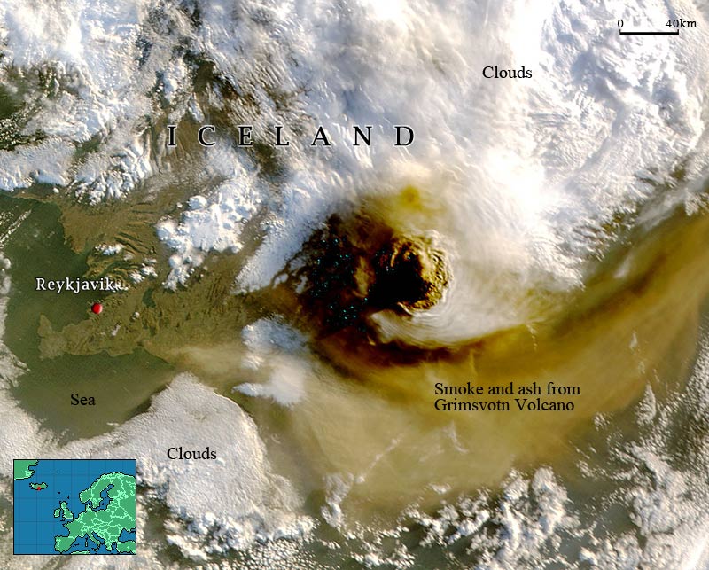
One year after the eruption of the Eyjafjallajokull volcano, another volcano, Grimsvotn, has erupted in Iceland, causing panic among northwest European countries. The latest eruption sent massive ash and smoke clouds into the air since 22nd May, 2011. This MODIS image shows the spectacular view of the volcanic eruption. The previous eruption cost well over $1.5 billion for the air transportation industry. Some airlines have already cancelled flights in northwest European countries. Even though Grimsvotn did not cause a similar scale impact as Eyjafjallajokull volcano, a potential risk remains.
Tohoku Earthquake and Tsunami
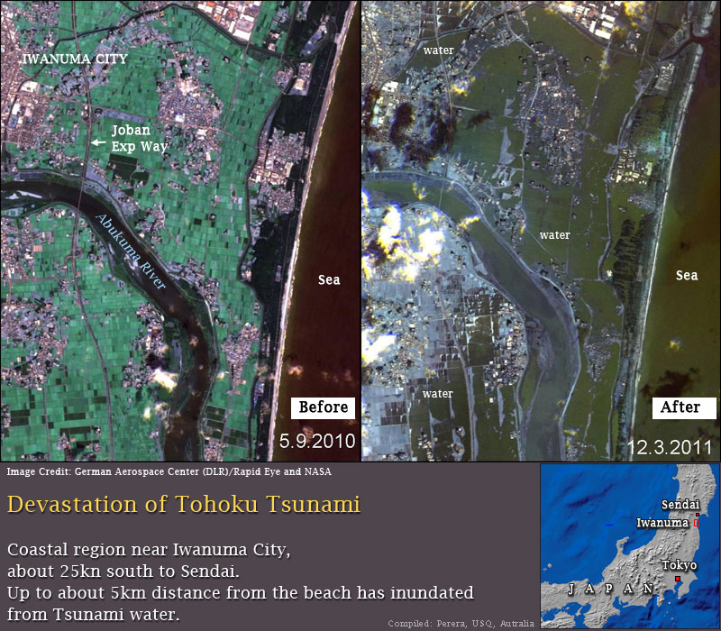
A massive earthquake hit the north-eastern coastal area of Japan on 11th March 2011, Killing 10,000s of people. The earthquake has triggered a giant tsunami, erasing many towns and villages along the coast. The extent of inundation from this deadly tsunami caused by the magnitude 8.9 earthquake is depicted in this satellite image pair. Sea water entered the land as deep as over 5km in some locations. Apart from the life and property damage, massive environmental damage or change has also monitored in the region.
Brisbane flood disaster
An unprecedented scale of flood has devastated Australia's 3rd largest city, Brisbane. Extremely heavy rains occurred for a few weeks in the region, causing deadly flash floods in Toowoomba, a mountainous city 120km west of Brisbane. The swollen rivers quickly turned into a massive flood on the already saturated soil in the rich farm lands of Lockyer Valley. Accurate flood warnings and weather forecasts have minimised the human casualties, but the economic damage to the region may pass AUD10 billion. The images show 2010 January 10th and 2011 January 15th conditions of the region. The brownish colour of the turbid water (over 15km wide in some places) in Moreton Bay is a clear indication of the massive scale of the flood. Compare the Moreton Bay in the two images. All white spots are clouds.
|

Geoguardian © 2005-2015. All rights reserved.