|
Geoguardian presents environmental contents based on satellite images and maps. This website deals with environmental and related research interests and is frequently updated with the latest environmental content. Kithsiri Perera - USQ, QLD, Australia, Since 2005 |
Environmental Contents Archive 2023 (selected)
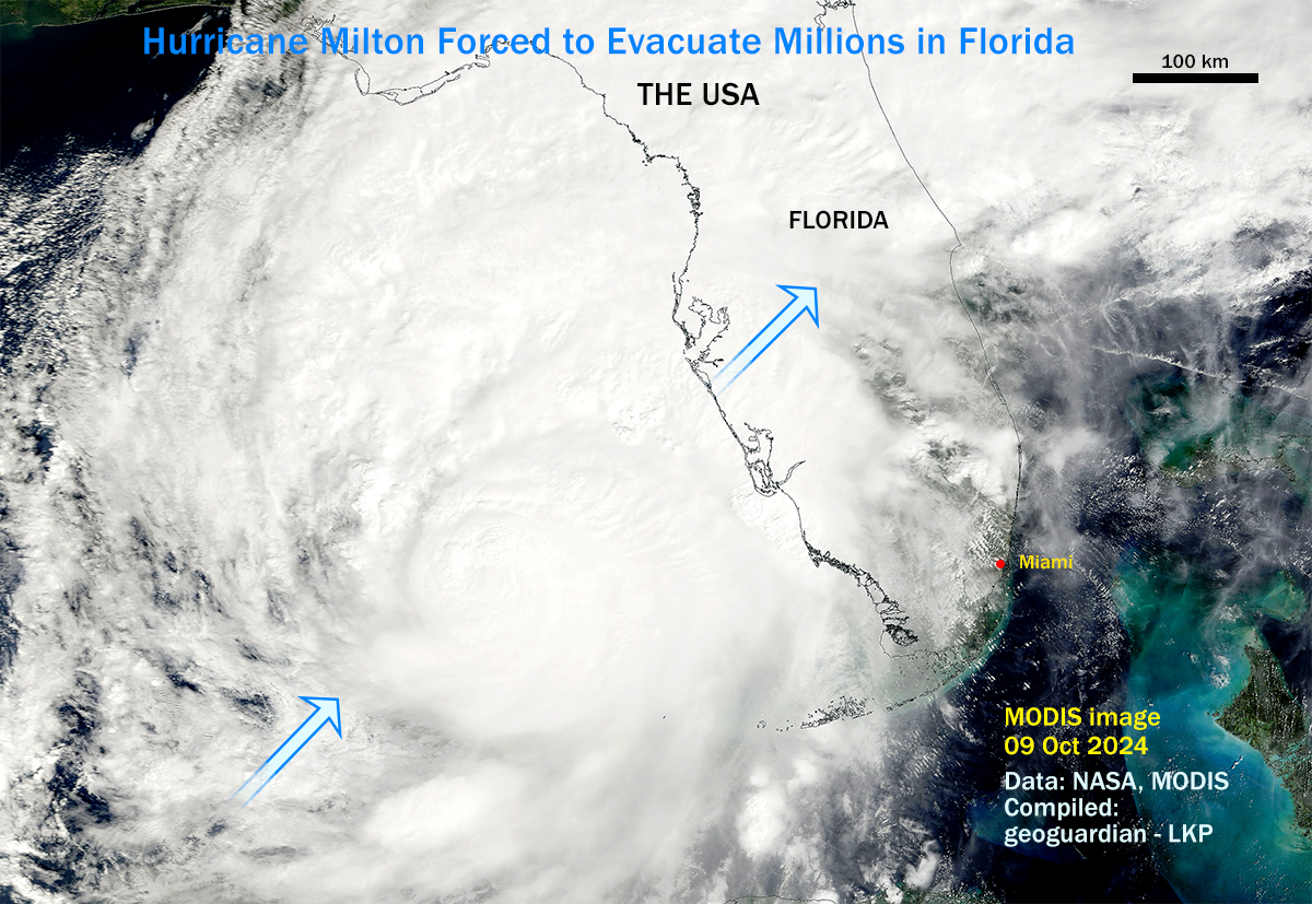
Hurricane Milton slams Florida
One of the largest hurricanes in recent times has hit Florida, forcing millions of people to evacuate. More than 2 million are without power as Hurricane Milton slams Florida, causing deaths and flooding in the region. Before Milton even made landfall, tornadoes were touching down across the state. The Spanish Lakes Country Club near Fort Pierce, on Florida’s Atlantic Coast, was hit particularly hard, with homes destroyed and some residents killed. However, the severity of the hurricane dropped with the landfall. Due to the scale of Milton, widespread floods can be expected. Check the SeeSatView app for an image of Hurricane Milton.
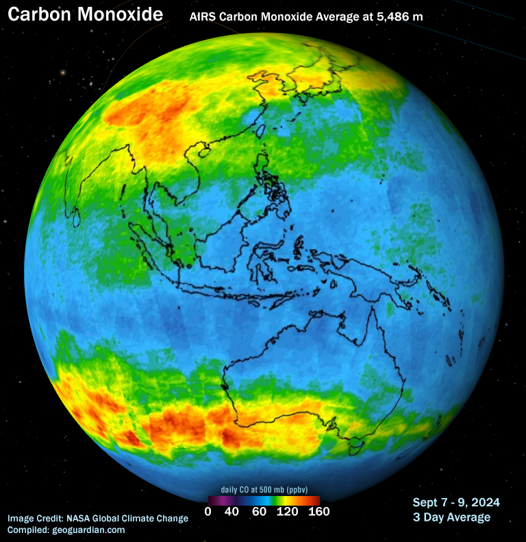
Carbon monoxide is one of the substances that the NPI (National Pollutant Inventory) tracks across Australia. Here are some fascinating facts about carbon monoxide and some hints on how you can help minimise any harmful effects of carbon monoxide on our health and on the environment. Carbon monoxide can occur naturally in the environment. It is released into the atmosphere by volcanoes as they erupt, from the smoke of forest fires, from the natural gases in coal mines, and even from lightning. Other natural sources of carbon monoxide are marsh gases, which are also called methane and produced by plants decomposing underwater, marine algae, kelp and seed germination growth. However, carbon monoxide is a dangerous, poisonous substance if people are exposed to it in high quantities. Source: https://www.dcceew.gov.au
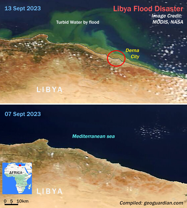
Storm Daniel, became the deadliest and costliest Mediterranean tropical-like cyclone ever recorded since Cyclone Nargis in 2008. In Derna, a northern coastal city of Libya, at least 10,000 people were confirmed dead after the Derna and Mansour dams collapsed, releasing millions of cubic metres of water and destroying a large part of Derna city. Images show a calm Mediterranean Sea on Sept 7th and the same region on Sept 13th after the storm hit. The turbidity in seawater by the flood is visible in the Sept 13th image. Check SeeSatView app for an image of Storm Daniel.
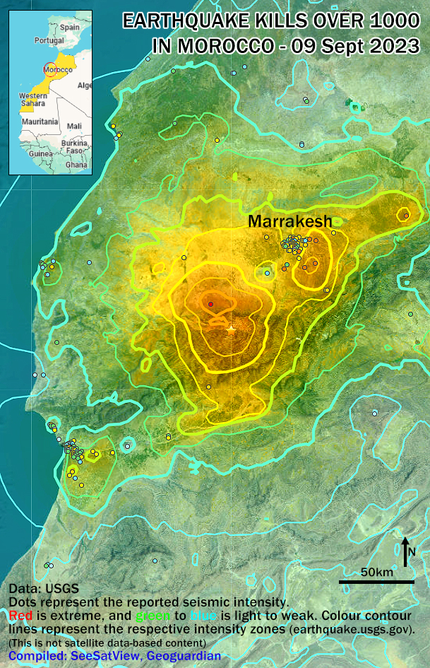
On 8 September 2023 a powerful earthquake of magnitude 6.8 struck Morocco at 18.5 km depth. The epicentre was in the High Atlas Mountains, 71km (44 miles) south-west of Marrakesh. Marrakesh, with a population of 840,000 inhabitants is most impacted city. According to media, severe structural damage with over 2,900 deaths were reported. The map shows the epicentre and the severity of the impact by various colour lines.
Lake Sylvester in Nothern Territory, Australia, was almost dry due to prolonged below-average rainfall in recent years. However, the region is green, and the lake has formed again after heavy rain in the last few months. Download and see these images in SeeSatView App (Educational and Free), which runs by Geoguardian.com. In SeeSatView, you can check surrounding information using the Google mapping platform.
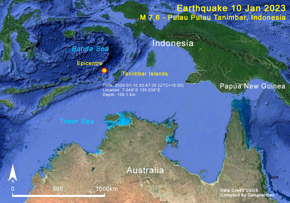
A powerful M 7.6 earthquake has struck near Tanimbar Islands in Indonesia, about 500km north to Darvin, Australia. Tremors felt in Darwin in the Northern Territory, Australia, and other surrounding islands. There was no warning for tsunami, from the earthquake, which was recorded 105km below the Banda Sea. If an earthquake of this magnitude hits closer to the ocean bed, a massive risk of tsunami can be expected.
|

Geoguardian © 2005-2015. All rights reserved.